By Jo Nova
The city kids don’t know the first thing about the sky
Despite the media frenzy here, no one seems to have noticed that the lost tourist, Carolina Wilga, was walking for 11 days in the wrong direction. She said she “followed” the sun, and thought she was going west, but she was actually going north-west, away from help. See the map below to appreciate what a terrible mistake she was making (among a list). At this time of year, the sun is setting almost as far north as it ever sets. Somehow she was missing the entire Wheat Belt of Western Australia.
Primitive hunter gatherers knew the cycles of the sun and the movement of stars we can’t even see. It’s the most ancient science and we seem to have lost it. Not just Ms Wilga, but all the commentators too. Neolithic Brits built Stonehenge 4,000 years ago to mark the solstice and modern phone bunnies with silicon chips have lost it. Heck, even Bogong moths can navigate by the stars.

Carolina Wilga, 26
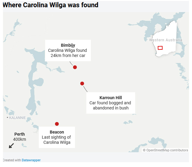
The 26 year old German backpacker drove 35 km off the beaten track into no-mans land and had an incident where the car slid, and she hit her head and got bogged. After giving up on the car, she waited a day, then walked “west”. She drank water from puddles and bee-hives. At night, temperatures drop to around zero (32F). No surprisingly, she was convinced she would die. It would have been gruelling and very very scary. On the 12th day, somehow, through extraordinary luck, or a divine act, the one sole station owner for 50 kilometers happened to see her on a dirt track that the owner doesn’t travel on much. Tania Henley (the rescuer) called it a miracle, which I thought was the usual hype, until I saw the map. Out in the border-land surrounding the vast desert center of Australia there are thousands of empty square kilometers.
The direction Carolina was headed in was almost doomed — running parallel to the northern edge of the wheat and barley fields in a largely uninhabited semi-arid zone.
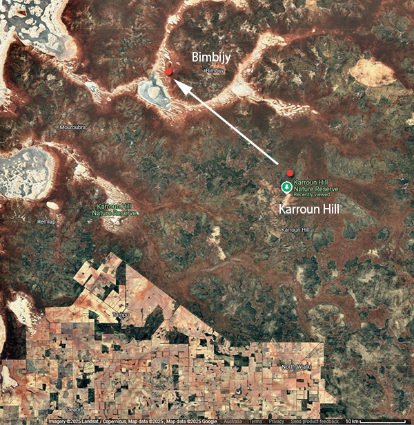
What the bland mass media map doesn’t show is where civilization is, and how she was headed in the wrong direction
In the satellite photo below we can see the wheat and barley farms to the south, where she had come from, and would have found safety and people. To the north and north-west is Bimbijy — which is one of the vast remote stations in Western Australia. (The red dots marking her start and end points are only approximate. The car was stuck in “Karroun Hill Reserve” which no one has ever heard of, but is 3,097 square kilometers in size. She apparently covered 24 kilometers on foot and was found west of Bimbijy, and her car was left 35km from “any established track”.)
Never mind the brown snakes, the deadliest thing out there is the lack of water. Rainfall in this area is less than 300mm or 12 inches a year and all the lakes are salt-pans. Luckily June and July are the rainiest time of year. One 73 year old gold prospector went missing in the same area last December, and sadly, has still not been found.
Headed NW to follow the Sun.
Ponder that the one cleared pale square under the word “Bimbijy” above is the station homestead and airstrip. The only one out there.
Tania Henley (the rescuer) said:
“It was meant to be because no one goes up and down that road. “I don’t go to Beacon very often…”
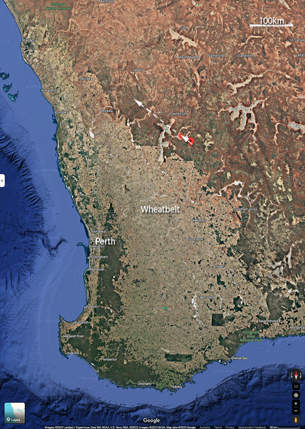
We can zoom out and see that by following the sun Carolina’s direction was one long miss. (Along the dotted white line). In midwinter at 29°S the sun is setting 23° north of west. Though obviously, she should have been going south west, not west in any case. (Don’t leave home without a paper map, eh?)
The golden rule is “never leave the car” but if you’ve somehow got stuck off road, 35 kilometers from any civilization, and no one knows you are there, or expects you home, and you don’t have a satellite phone or an emergency beacon, then all your choices are bad. Spotter planes will find a car faster than a person, but if no one sends out a spotter plane, it might be weeks or months before another car goes past. As it was, her car was found only one day before she was.
Lucky Tania Henley didn’t leave an hour or two earlier.
This is still in the news here in Western Australia every day, because obviously we were delighted she was found. I’m just amazed that no one has mentioned the sun…
A young German got lost on a trail,
Surviving 12 long days but frail,
Very lucky to last,
Where the outback is vast,
She can now tell her ‘walkabout’ tale.
— Ruairi
POST NOTE: Her gracious note from the hospital bed. She is one immigrant/visitor who sounds very Australian.


Not just city kids – I’m officially old and while the information was buried in my brain somewhere I doubt I would have actually considered the sun’s north/south inclination while trying to head east or west.
However, thanks to this learning opportunity I’ll be sure to get it right the next time I’m lost in the middle of a desert.
391
It is not clear to me why Carolina chose the area to go backpacking – with a car. Where did she start from? I have hiked and ridden horses in some fairly odd places and can think of at least 6 things she failed to do.
Had she come to OZ recently? Friends – where? Where did she get the car, etc. Many questions. Maybe she will write a book.
A good ending.
230
It’s a very odd corner to explore this park. Impressive for a German when I would guess 99% of people in Perth have not been to Beacon or anywhere N-East of Perth past Toodyay. But north-east of Perth is the invisible zone. The land time forgot. I quite like it.
(I have camped at Elachbutting Rock, not that far away, which is a great spot and only 3.5 hrs from Perth. But even in Oct school holidays there were only about three cars there).
The word is that she’s backpacking around Australia for 2 years, but I’ve also seen it mentioned that she “hasn’t been to the Eastern States yet”.
For about a week in WA the search was a top story here daily, because of course, we all hoped they’d find her, and were delighted and amazed when they did. I had hoped it might spring a big discussion on safety, survival, and navigation, even basic awareness of “the sun” but it doesn’t seem to be.
581
Joanne puts this perfectly
When I visited Perth recently, my Sister took me on a day visit to The Pinnacles, around 2 hours to the North of where I was staying at Merriwa. I had no idea what to expect, and when I asked my Sister what to expect, she (cleverly) mentioned Queensland’s Glass House Mountains, and here, the only resemblance was ‘things’ poking directly out of flat ground.
Once we actually arrived there and I saw it that initial time, well, that was a revelation, but what surprised me most was the distinct lack of people visiting this wonderful tourist attraction. Whilst there, and walking around the ‘path’, we encountered only four other groups of people, (mainly at the half way Lookout area) and three of them were from the U.S. and the other was also from ‘back East!’, like me. At most of the time during that more than an hour walk around the designated (sort of) path, we could see no other people at all.
This is the link to my own Post on this fascinating attraction
We made a day of it, also visiting nearby Cervantes, and Lancellin as well.
Another startling thing was the almost complete lack of traffic we saw on that (I suppose) major highway, Indian Ocean Drive. Virtually the only vehicles we saw were all travelling in the opposite direction. And what that of itself made me think about was electric vehicles and their introduction here in Australia. Fat chance that happening in this area. (eg, anything at all North of Perth)
No word of a lie in this, nine out of every ten vehicles we did see travelling in the opposite direction were all large scale 4WD vehicles, and a third of them were towing caravans. We were the extreme outlier in a small sedan.
It was also an astonishing landscape, with quite literally millions of, umm, grass trees, and didn’t I get the usual eye rolls from everyone when using that now woke term. (Please Tony, call them their correct name of what they really are! the name the Aborigines themselves refer to them by) Also, the most pure white sand dunes I have ever seen, around Lancellin, and along that highway
It is desolate land and I would hate to be lost anywhere in it, even knowing how to find directions, something my Mum taught me as a ten year old back in 1961, lying on my back on that night on the protruding concrete septic tank in the back yard as Mum taught me how to find due South from The Southern Cross, and then during the day how to use a watch to find North. That’s something that amazed a real estate agent in Rockhampton. I didn’t have a watch on, so I asked her the time, and when she told me (around 4PM in the Afternoon) I just imagined a watch on my left arm, and located North. She couldn’t believe it when I told her how to do it. She even asked the question I actually expected. What if it’s a digital watch? Every new residence I have ever moved into, that’s the first thing I do on the first night, look for Crux and find South.
And the original Three Body Problem, think of the brightest star in the sky, (after our own Sun) Alpha Centauri, the bottom Pointer. Well that’s actually three Stars.
Tony.
190
>call them their correct name
What actually IS their politically correct name?
I know them as Xanthorrhoea Australis.
Back in the ’50’s & ’60’s we used to call them blackboys so I thought grass trees WAS the PC term, but seems I was wrong.
What IS it?
60
Yes, you have the Genus correct, but that’s for the one most prevalent in the East. The WA one is Xanthorrhoea preissii, and to my absolute astonishment, they’re not only endemic to WA, but everywhere I looked both sides of the highway North (for more than 100Km+) and all the way there, and out to the horizon, virtually both sides of the highway, with barely one metre between one and the next closest one, so, many hundreds of thousands, and probably millions is my best guess. All there was in fact. As you got closer to Perth there was that other tree endemic to WA, and also almost everywhere across the South West, the Marri, Corymbia calophylla, (formerly a Eucalyptus) with their beautiful white flowers the bees love so much.
Grass Tree IS now the Politically correct reference, but they are called blackboys, and even the aborigines refer to them only by that latter name, and say they were NEVER referred to as Grass Trees at all, our own PC invention.
The ones I saw were all blackened by the great Lancelin fire which raged for weeks not long before I had my visit. However, they actually need fire to germinate, and you could see that the fires hardly touched them at all.
Tony.
100
Thanks Tony. I enjoyed the visit to this strange place.
30
Back in the day, they used to teach people to tell others where they were going if going to a remote area, always carry plenty of water, food and supplies, compass, stay with your car in the event of breakdown, and these days to carry a GPS, battery pack for phone and Emergency Position Indicating Radio Beacon (EPIRB) for marine use or a Personal Locator Beacon (PLB) for land use. (If it was me as a radio amateur I would also carry a radio transceiver.) People also knew that the position of the setting sun changed with season, way back when.
There is no excuse for not having a GPS or compass. It’s best to have dedicated ones but every phone has them and there are free offline map apps like OsmAnd which work without a data connection.
Frankly, I’m impressed that she even knew that the sun set in the general direction of the West despite getting the specifics wrong and she was prepared to drink from puddles, not a designer label bottled water, and presumably braved getting stung from getting honey from beehives (but native bees are stingless but not all produce honey).
Current sunset direction at 29°59′11″S 118°13′23″E is 294 degrees.
I’m glad she got rescued.
381
I have carried a Garmin InReach in my pack for a couple of years. It allows me to communicate via typing through a satellite after sending a SOS, and transmits my location. Monthly fee. Haven’t had to use it.
Also, when out of range the apple iphone can send an SOS.
200
Yes. Apple uses the Globalstar satellite network and the feature is not available in all countries but it is available in Australia. For iPhone 14+.
https://support.apple.com/en-au/101573
130
InReach has been available for 10+ years, first as a DeLorme product. A 2-year packer ought to have such a thing.
60
Its worth knowing that HEMA maps app works for location even without any mobile company signal. In my very ordinary android phone I used Hema Maps to travel through the desert past Warburton, Giles, Docker River and Ayers Rock. At any time I could ask the lat and long, and my phone would tell me the answer to at least 5 decimal places. Out in the desert for 1000km there was no Telstra or Optus signal, but the phone still knew exactly where I was, and also told me how many satellites it was using to triangulate the position.
Back in 2019 there were between 13 and 21 satellites in the sky at any one time. It was pretty weird to stand in a spot at night where there were no humans for hundreds of kilometers and still have that kind of detail at my fingertips.
The only catch with Hema maps was the time it took to download very detailed maps, which had layers of street/topography/other information before the trip. Their packages are here, though it sounds like they have changed the subscription model and people are not happy. https://hemamaps.com/collections/4wd-maps-app
40
There’s talk that Musk satellites will give Telstra true continental coverage, rather than the marketing maps shown now, which will be extremely welcome. Further though is the suggestion Telstra will restrict most of that to emergency service, which is ridiculous. The ability for this girl to advise her car had broken down and gps locate her phone would have conveyed how critical it is to stay with her car.
User pays…thru the nose in Australia for the privilege of technology service other countries take for granted. Maybe Bobowen can add phone towers along with his taxpayer funded high transmission lines and we can have 2025 communications in remote areas, as we de-industrialise and revert back to 1925 lighting and power?
80
I met a German chap in the Flinders Ranges in the mid 1990’s and he had a GPS. fascinating I thought as I didn’t know they existed. Always found Germans a very intrepid bunch who go in for the real adventure. Malcolm Douglas was very popular in Germany and his outback forays were well watched.
30
Yes, a great outcome, considering she broke just about every outback rule and just dumb luck that the woman happened along that road at that time.
The Southern Cross is a good indicator of due south but it’s a bit much to expect a German national to know that.
190
“Southern Cross” is a song by the rock band Crosby, Stills & Nash, released in September 1982.
61
All ways though that a Southern Cross was an angry Texan!
Cold clear nights here in the low part of the Victorian high country, the southern cross rises over a big hill behind the house, when its directly over head it appears to be in reach. Great nights with friends and a fire ” Under the Southern Cross”. Google it if you need a laugh
40
In reality , I doubt many folk know how to identify the Southern cross, let alone use it as a navigation reference.
Whilst i am relieved she has been rescued, i am irritated that she is being hailed as a resourceful lost traveller.
She dramatically reduced her chances of survival the moment she left her vehicle, leaving behind shelter, food , water, etc.
I can only assume her reason for that decision was indeed the head knock she claims to have suffered.
141
I noticed there is a repeater station about 50 km south of her car, not sure if it was a UHF repeater or not, could a 5w handheld hit that repeater.
50
At 5W maybe VHF not sure about UHF assuming it’s all line of sight. 10W would be better of course.
00
The main point being from the northern hemisphere her South is our North. She got the West right.
150
Yes, that can be quite disconcerting.
You know the sun is to the north (or south in the northern hemisphere), but it doesn’t feel right. It totally throws the sense of direction out.
Even something as simple as the 4 degree latitude difference between Sydney and Melbourne throws it off.
120
Same feeling about having the ocean to the west, rather than the east, when from the eastern states. Does your head in….
00
As soon as we first came to Australia I noticed that the sun moved in the opposite direction from East to West via North, rather than via South. Also, of course, shadows moved the opposite way (important when parking the car in the summer sun). Also, woe of woes…Orion was upside down! We also recognised the Southern Cross very early, with a camping trip to the NT.
220
I got lost in LA once because I drove north instead of south because the sun was in the wrong position for my southern hemisphere brain to compute. Way before satnav too. Easy to do.
30
Well not really, as the sun rises in the East world over. She would have been spot on regarding west if it had been the 21st of March or September. If it had been December 21st she would have accidently headed in the right direction for finding people, not accounting for the major water problem tho.
30
It would be forgivable if her German sense of the sun was upside down. When I first moved to the Eastern States I got North South 100% wrong on the coast for a few weeks. I didn’t realize my head-map had sunrise and sunset locked to a West Coast aerial view. I *knew* the sun rose over the hills and set over the beaches. Hence my north-south sense was screwed. I improved the brain model. Was a head-spin.
I wish someone would ask her if she was surprised where she ended up?
30
True I live on a cattle station so my ‘head map’ is pretty good. But after a life time on river systems that run south west, I brought a property where the water shed runs north (rare in western QLD) It took nearly 6 year before I ‘automatically’ knew north from south and east from west. I knew were I was on the property, but I’d say to the crew ‘Take the mob east….sorry I mean west’
30
On my only visit to Australia in the ’80s, my sense of direction was “off”. I would depart a building in the city (any city) and turn the wrong way even though I was careful about checking a map before leaving. I am quite experienced with maps and orienteering but never got the hang of finding my way in the Southern Hemisphere. It wasn’t until I returned home that I realized that the main clue of direction finding is how shadows are cast. In the Northern Hemisphere the shadows are cast to the north. Direction finding down under was completely counter intuitive to me and I didn’t grasp why until later. Fortunately I didn’t stray far from the roads on my trip from Melbourne to Alice in a rented camper/pickup truck. And I was able to climb Ayers Rock. Best.
10
Generally, people her age will know all about supposed climate change, the multitude of genders, the evils of Western Civilisation and capitalism, have few practical or marketable skills, will be physically and mentally feeble, and will know little to nothing about nature and survival therein.
She did much better than expected of someone her age.
331
Note that Elon Musk is expanding Starlink with a service that will allow you to connect to his satellites from anywhere with a 100% standard mobile phone for the purpose of text messaging (not voice or data, yet).
In Australia Telstra will be the local operator but I’m not sure if the service has started yet in Australia.
This will be helpful for people in emergency situations.
(Those with Musk Derangement Syndrome should not use this service.)
290
I’ve heard the grey nomads are taking Starlink up like crazy.
170
I have a friend who couldn’t get satisfactory NBN service at home in Melbourne and ended up switching to Starlink and is very happy with it.
140
No Signal, No Worries: New Telstra Tech Sends Texts Anywhere
Dan Everett July 8, 2025
In a move that could change the way Aussies stay safe and connected in the bush, Telstra has just launched Australia’s first direct-to-satellite text messaging service, and while it’s a long way from perfect, it’s also a big step forward for anyone heading off the grid.
Using low-Earth-orbit satellites (LEOsats) via a partnership with SpaceX’s Starlink, Telstra’s new tech will let users send and receive SMS messages even when they’re completely out of mobile range with no need for bulky satphones, spot trackers, or external antennas.
What’s the catch?
At the moment, it’s only available on the Samsung Galaxy S25 (so if you’re still running a dusty S10 with a cracked screen, you’re out of luck), and the service is limited to text messages only. No calls, no photos, no triple-0.
It also won’t work if you’re in a gully, under heavy tree cover, or can’t see a clear patch of sky. And even when it does connect, the message might take a few minutes to send, depending on satellite positioning.
But still, it’s a taste of what’s coming.
Telstra says more devices (including iPhones) are on the way, and that voice calling via satellite is expected by 2027. There are also no extra charges for the text service. It’ll be bundled into standard postpaid plans.
Why it matters for 4X4ers
If you’ve ever broken down, lost GPS signal, or had an emergency out past the black stump, you’ll know how bloody isolating it can feel. This kind of tech could be the difference between a cold night in the swag or getting the help you need when something’s gone pear-shaped.
Mining and exploration crews are already buzzing about the potential, and solo tourers, grey nomads and remote station workers should be too. Even just a basic text saying “all good” or “send help” is a game-changer when you’re a few hundred kays from the nearest phone tower.
What’s next?
Other telcos like Vodafone and Optus are also working on their own satellite plans, and the federal government has hinted that satellite texting might become part of Australia’s universal mobile service obligation by 2027, meaning it could be a requirement for all telcos to offer it alongside mobile and fixed-line services.
That would make Australia the first country in the world to legally require nationwide satellite coverage. And while the technology still has a few teething problems (patchy results in the US have been reported), it’s improving fast.
For now, it’s a promising start. It won’t replace a PLB or a full satphone setup for serious expeditions just yet. But it might make your next solo trip into the desert a whole lot less risky.
130
My son works at Yulara (Uluru – Ayer’s Rock) and has ditched his sat phone for a Starlink system.
He is planning on placing an antenna on his car roof. As these use a phased array they self-align to the satellites.
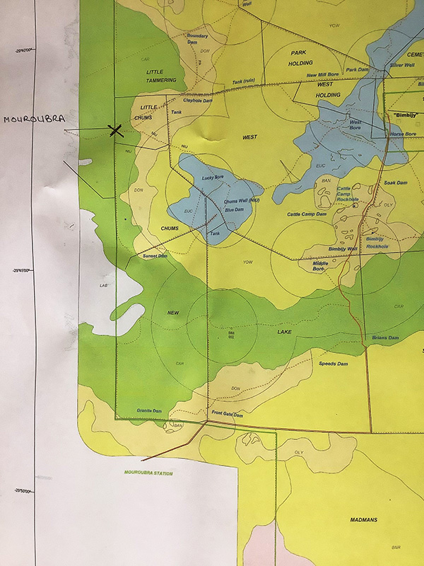
I also cannot see any roads anywhere near Karroun Hill so how did she get there?
50
No doubt tracks everywhere. We had tracks in all directions on the Nullarbor, none of which are shown on Google maps. In fact I doubt that most of them were ever plotted on any map.
50
Good question, she was definitely “off the beaten track”. If you watch the video, the camera shot of her vehicle, which had ploughed into scrub, zooms out and reveals the rugged terrain.
It is odd that someone would be travelling solo without some of the emergency communication gear mentioned above by others. I hope there was no attention seeking motive behind all of this
https://www.abc.net.au/news/2025-07-11/missing-german-backpacker-carolina-wilga-search-update/105520682
30
Irresponsible travellers like her should be billed for (part of) the cost of the search.
00
Most phones have Google maps or the equivalent. These only require access to an open sky, not a phone signal. Surely she had a phone that she could have used to guide her back to civilization. Maybe she left it in the car, big mistake. Most cars have a USB port for phone charging so it should have been usable at the time.
81
Bernie, of you don’t have a signal, they only work if you download Google Maps in advance for the specific area you will be in.
They absolutely will not work if you don’t first download the maps.
I use OsmAnd for my offline maps in all countries I visit and Australia when in remote areas. They too must be downloaded in advance.
70
David, what you say is correct if you fly into a distant location with your phone off you need to preload maps if you will not have a signal with data there. But if your phone is on, in say Beacon WA, with a signal, the Google maps will normally be tracking you and and updating as you go. The map area would normally have a radius of 50 km or more. She may have had her phone off and then maybe no map updates, we don’t know. She said she was confused so anything could have happened.
40
If she had a signal she’d phone someone
80
She could have had a signal in Beacon when she was there but probably no signal where she got stuck. There is a good chance her phone had working maps before she left her car. After 12 days she would be lucky to still have a phone that worked.
30
Telstra Map coverage says No to Bimbijy and No to most of Karroun Hill. https://www.telstra.com.au/coverage-networks/our-coverage
Sometimes climbing a rock might get a bar of signal, but if the tower was in Beacon, probably not.
00
I always download goolag offline maps before I travel to other countries. Except China – goolag is blocked.
10
No…I’m not surprised. I worked in the disabilities field for a while – with a lot of young adults who were all expected to do a bit of driving. I was amazed to learn that most of them could not leave the driveway without some cue from their phones. They literally had no idea where they were or where they were going. And of course they didn’t even know how they got there in the first place. They could not even talk in terms like N-S-E-W. I still have a roadmap in the car because I like to know where I am going but these “kids” had probably never seen one. It was the only resource you had as a teen on the road back in the day. Some of them didn’t even know hot to open a car door if the battery flattened on the key set. Standing there in a panic. Never opend a car door with a key. Not knowing where I am at any given time is anathema to me but it’s how thay are doing life.
241
Are these ‘disabled’ people Matt or are they support workers, if the latter then we are in big trouble as a nation.
130
“Staff members” I am referring to. Bright young minds….many with degrees or close to getting one.
150
Wow, that is bad.
90
Two instances of the concerning current ignorance of our world:
1. A young woman engaged in maritime activities giving directions to ships captains by radio, believed and adamantly refused to be corrected that the compass points ran clockwise around from North to South to East to West. Consequently when giving a direction to head “South”, she expected the ship to head (in the direction that has always been called) East.
A Navy drop-out at that, and graduate of a maritime school shipping agent course.
2. A mid-teens person who had no idea why we have seasons. The seasons were simply accepted as happening.
Back in my primary school years, these basic facts, and many more, about our world and its functions were taught as a matter of course. Being able to navigate by map and compass, understanding magnetic variation, finding celestial South by the Cross and Pointers, finding North using an analog wristwatch, being able to draw a reliable map of your location or area, geographical awareness were all standard fare, certainly in rural areas. The curriculum would have been the same state-wide, including in the cities, and probably similar in other countries in the same era.
I do worry for the young of today. They are not only not understanding the physical world they live in, but so many don’t seem to get out and enjoy it the way we used to. OK, I’m heading towards annoying late middle age/impending old age, but the physical world hasn’t gone away or changed.
120
I enjoy maps, paper maps, large scale and full of tit bits of other information like railway lines, roads, geographic features, mine sites etc. None of this information is available on small screen devices. Sure they offer direction, only till they go flat, still it’s the modern world. One very lucky lady.
200
I’ve always loved proper maps. OS my favourites (Ordnance Survey).
We still keep a Melway in the car.
120
Had a need to attend a wedding in Sydney Annie, kids programmed the directions into the magic device, Grandpa took his “Sydways” published in 1970 something and had a read up the night before. Made our destination without any problems and somehow managed to avoid all the toll roads that weren’t there when the book was published.
31
On an early visit to Sydney we had the UBD…I didn’t think it was as clear as the Melway. I don’t remember a Sydway being available at that time (Christmas 1984).
10
I am a die-hard map nerd. As much as I dislike Gulag, the Google maps and satellite view are like a surreal gift I am drawn to again and again. To zoom in and out to really understand. What Kings and sailors and generals would have paid a ton for gold for…
I treasure my paper maps, and the aerial map I carry in my head. For years I had no idea that some people didn’t have a head map. It was like a radical concept when a friend said, wait, how did you know where that street will go if you’ve never been down it?
It was so obvious that it went west and had to hit Wanneroo rd. She was shocked I would turn down a random street. I was shocked she wouldn’t.
70
I did an Outward Bound course in North Wales for 3 weeks when I was 19. One part of the course was a 3 day hike across various mountains. To help us find our way from point to point we were given an Ordnance Survey map of the area. I was the only one in my group who could read and understand it. The group I was with always got there first.
50
A few Paris-Dakar have been won by the superior navigation of the winning team – all who do it show similar levels of grit and determination, but the technical knowledge can take the prize
30
As a kid I was a bit of an Atlas nerd. I loved the idea of all the starangecountries and places.
When we moved to Melbourne in the early 80s the Melways was a bit of a revelation with its State, region and regional city maps in addition to Melburbs. Just the thing for new arrivals exploring.
30
On arrival in Melbourne in 1984, the first bit of advice we received was to buy a Melway; great advice and was a fantastic help to getting around the city.
30
We have quite a collection of maps piled up on the study shelf!
10
” (Don’t leave home without a paper map, eh?)”
At least paper maps don’t depend on a charged battery and a signal.
180
Whenever I go to the bush I always take a paper map and non-electronic compass, apart from other items.
150
Toilet paper
00
That’s always helpful too!
10
It’s very disconcerting to go to the Northern Hemisphere because the sun is in the wrong direction. Your instinctive direction is wrong. I think she thought she was heading South West, which was right. But in fact North West away from civilization.
People with a strong sense of orientation, people who look up instinctively get this wrong. Men in my experience. It’s a strong instinct, embedded, reflexive. Hunter gatherers. North and South are flipped. For an American in the outback, the one thing they know without thinking is that low sun is South. It’s built in. The Sun is setting in the South West.
On my first business trips overseas moving quickly, driving, it was disconcerting to have the cities upside down, North and South flipped, but you learned to adjust. You had to flip to drive on the other side of the road as well. And in city streets you can feel lost on foggy days without the sun, no reference point. Years before good street directories let alone GPS and smartphones.
Then on a trip to Las Vegas and hiring a car, everything was completely wrong again. It was the map I was given, a simple helpful sketch plan with an arrow pointing upwards. Everything was wrong again! So when I returned the car I asked and the owner said he drew the maps upside down because it made more sense to him.
150
Many men pride themselves on their innate sense of direction. They can be very disconcerted by swapping hemispheres.
I have also know people with zero sense of direction, often women who would happily admit to getting lost in a revolving door. For such people you abandon NSEW, left and right completely and give directions entirely in terms of known or recognizable landmarks. The Post office for example. And then head to the supermarket.
And one of the most important features of outback Australia is that there are very few features and zero landmarks. Unless you have the extraordinary instincts of an aborigine who can recognize near flat terrain. They can recognize locations from the slightest of bumps. You would think getting lost in a desert is hard compared to a tall forest. But it’s quite easy.
170
Try driving around on the actual Nullarbor Plain. As it’s not completely flat, it only takes a few kms before any signs of civilisation disappear from view. Even any tall mast or water tank can’t be seen after about 30 kms in summer, due to heat haze.
70
I asked one of the local policeman’s wife if they would get the Black trackers in. Apparently there not any of them around now 🙂
60
They’ve all got Welcome to Country gigs, now.
Or so I’m told.
A much more reliable and regular form of income.
Apparently.
120
Almost all the women I know, when asked which direction their home faced had no idea, even when asked where does the sun rise in relation to various windows and doors.
Have you ever watched a woman use a roadmap or a Melways or Refidex when out and about, just fascinating.
Not trying to be sexist or anything.
60
As the saying goes ” I never get lost as everyone tells me where to go!”
30
“The knowledge” actually gives London taxi drivers brain changes over time: https://pubmed.ncbi.nlm.nih.gov/34914151/
Licensed London taxi drivers have been found to show changes in the gray matter density of their hippocampus over the course of training and decades of navigation in London (UK). This has been linked to their learning and using of the “Knowledge of London,” the names and layout of over 26,000 streets and thousands of points of interest in London.
40
Not all women.
30
A mans directions.
Drive for about 1.5 k’s, then turn left down Boundary Drive, drive another 500 meters, turn right into High Street, then straight ahead at the roundabout then at the next round about, make a left turn into Close Street, it’s on your left about 200 meters after your last turn.
A woman’s directions.
Drive straight up this road until you see that lovely dress shop, “Miss Class” on your right, turn left there, drive until you can see that fabulous shoe shop, “Clogs”, turn right there, go up to that round about, past the KFC, then a left turn at the next roundabout, then the place is opposite that bright yellow Beacon Lighting shop.- I guess using familiar landmarks is not as crazy as it seems…
60
An Irishman’s or Newfie’s (Newfoundlander’s) directions
: You go five miles down this road until you come to a fork, then you drive straight on!
20
Asked an Irishman how to get to Cork, he started his directions by saying ‘if it’s Cork you’re wanting to get to, I wouldn’t start from here’
10
I had a friend in Sydney who gave directions based on what pub is it near
50
Only 24km in 12 days – she spent a fair bit of time wandering in circles. Very, very easy to do I’ve crossed my own tracks it scrub country more than once.
10
I’ve been to Las Vegas a couple of times and each time although the ‘strip’ runs generally north/south, it feels upsidedown to me, I know some landmarks are to the north but when out walking, they feel south.
40
That seems quite on the cards. Even though she’s been in WA for a couple of years, knowing that the sun was to the north didn’t counteract a lifetime of it being to the south.
That’s probably what caught her out.
40
Sad tale but true: In 1978 I was driving west on the Esk Main Road, Tasmania from St Mary’s through the Fingal Valley. Near Avoca I came upon a head-on car crash. The woman in a HR Holden was deceased with the imprint of the steering wheel stamped into her forehead. The other car was a rental driven by an American tourist. He suffered an ankle injury.
The American tourist had been visually sucked in by the meandering hilly country road with very little traffic to indicate “keep left”. He had forgotten his bearings and had been driving on the wrong side, directly into the path of the local woman driver.
60
It’s very easy to do. I used to change countries frequently. Not only when you are in another country but it is also very dangerous when you come home!
My solution is when you are adjusting, stick behind other cars as much as possible until you are fully acclimatized. Even one other car in plain view on either side and you wake up. Or you can just forget where you are.
Also works for multi lane split carriageways as in America like Los Angles where they are rarely signposted and you can end up on the wrong side driving head on into the traffic. Follow that car works. The very dangerous problems appear when you start to relax and your old habits drive the car. Which is why they have signs on the Great Ocean rode that you drive on the left. People just forget when they relax, crest a hill or turn a corner and it’s all too late. In WWII in England it was a major cause of deaths.
I also warn about pedestrian crossings overseas, as Australians and Americans both look the wrong way. Right, left, right again becomes left, right, left again!
30
Yep did that one night in small town Texas. The biggest danger was nearly getting shot by sheriff, because I got out of the car when he pulled me over.
10
>You had to flip to drive on the other side of the road
Many times when overseas I inadvertently came within a whisker of death, felt it brush past me at speed when I was just about to step off the kerb having stupidly looked to the right.
You have to look to your left in countries where they drive on the RHS. Buses can be travelling quite fast only inches from the kerb. I must have a guardian angel.
10
I recall that the cases of e.g. falling off a cliff in the mountains in mist/fog (having wandered off-track) and killing themselves are often German tourists (in New Zealand). The German angle is one that I suggest is deserving of more interest.
70
People of this nationality also figure highly in crocodile attacks
50
Johnny Weissmuller was of German origin.
50
Please, someone get this!!
20
Survival skills are alt-right.
130
The left are not into selfhelp or survival, there’s always ‘someone’ who will help/rescue them.
90
The following YouTube video is about this guy who asks Gen Z people in the street general knowledge questions.
One of the questions asked is to name the cardinal points on a compass and the person couldn’t. (Not saying that’s the case with the German girl who’s the subject of this thread. She clearly had more of a clue than others her age.)
The cluelessness of Gen Z is frightening. I assume this is in New York judging from the 212 area code on the garbage truck.
I bet none of them are MAGA voters!
https://youtube.com/shorts/tcgU_4BPc7c
71
The disconnect from reality is just astounding, fancy not knowing that Canada and Mexico border the USA.
50
Once on a cruise ship from Vancouver to Alaska, the adult Americans at our dining table did not know the names of the States that bordered their home State of Montana, let alone the name of the bordering Canadian Province.
90
I used to work in a bank at Heathrow airport in the early 70’s, the terminal was terminal 3 which was for arrivals from anywhere but Europe and the UK. Believe it or not I would occasionally get asked by Americans if I could speak English.
70
Not sure today’s default “bushcraft” education can be much worse than I got in primary school in 1960s Newcastle. We had various bits of (presumably Northern Hemisphere) reading matter giving us tips about moss growing on the north side of tree trunks and the like.
Admittedly we did hear about Burke and Wills, who weren’t quite as lucky as young Carolina. That was a useful message. I see Wills was only a year older than Carolina when he didn’t make it.
130
Back in the day, their ABC used to have a program with Jack Absolom telling us about survival off the beaten track in case of a breakdown, it was astounding the things a car has that you can use to survive, the main thing was to use the car for shelter and to have a fire going and to make lots of smoke, station owners can see smoke from far away and will usually investigate it.
110
One trick was to make a fire with old car tyres. The dense black smoke was easier to see over a distance.
70
If you have a Battery Electric Vehicle then you have the perfect means to start a very smoky fire that will burn for hours!
120
About all it’s useful for out there.
40
A car has three good mirrors, good for signalling aircraft, the air filter housing will usually hold water so will the wiper washers tank, if the transmission is U/S but the engine still runs and you have fuel, you can make water via the A/C system, just locate the drain and slip a receptacle under it, the spare tyre/s will burn well and make black smoke.
While newer cars are very reliable it doesn’t take much to disable them, if an alternator fails, you won’t go far, or a black box type module for the fuel or ignition fails you’re cactus and there’s no workaround like cars of old.
Even something like a fan belt or cooling hose failure, if you don’t have spares and tools you’re stuck.
20
Two years in Australia, much of it in WA working at mine sites.
It seems she had not been drawn back to her homeland in Europe and found the simplicity and isolation restorative.
Who knows.
Even twenty five years ago Italy and Belgium, as examples, were starting to show signs of “heading in the wrong direction” and Europe isn’t somewhere I’d currently go for a holiday.
Maybe she viewed her time in the outback as relatively safe.
She’s done well.
100
She should buy herself a lottery ticket, also she now knows lots more about the bush than a lot of us locals do.
60
Who knows what she was thinking.
The obvious thing would have been to walk back the way she came in.
Why was she heading in there?
50
Yes thought the same thing, follow her car tracks.
20
Back in my rock kicking days we had 4WD Landcruiser flat tray vehicles: no aircon and no power winch, just a hand operated Terfor winch and a radio device for calling back to base twice a day (not on weekends as the Perth office was closed). The exploration area was at Millrose Station some 70 km east of Wiluna on the edge of desert country. Most evenings were spent repairing the 6 flat tyres that were staked during the day’s grid soil sampling. There was no thought given to training in bush craft, first aid , 4WD mechanics.
Getting bogged was testing: if there were no trees to hitch onto then fence posts or metal stakes belted into the ground were options when no other 4WD was at hand to offer a tow.
When all was lost you had to walk 20 to 30 km for help especially when bogged on the weekend when the base office was unattended. Once on my own I luckily came upon a water tank. Looking forward to slake my thirst I was horrified to find that the water was rich in epsom salts!!!! Yuk. No OH&S in those days.
90
A young German got lost on a trail,
Surviving 12 long days but frail,
Very lucky to last,
Where the outback is vast,
She can now tell her ‘walkabout’ tale.
170
I’ve worked in the bush all my life predominantly within the eastern Oz states. Thanks to half a generation of experience utilising basic orientation skills viz. compass & map, dead reckoning, visual landmarks etc & more recent GPS positioning, i haven’t ‘as yet’been 100% lost. However, can relate to physical senses disorientation upon 1st visit to WA where the sun sets over the sea! Also had issues when navigating in Nthern hemisphere using a Sthern hemisphere compass (pre-GPS), needle would catch against the housing when compass held level.
50
I found the same when working in Perth for a few months, we would go somewhere and end up at a ‘T’ intersection, almost always turned in the opposite direction, soon realised it was because the ocean was to the west, whereas it’s to the East at home in Brisbane.
20
Having also been bogged on the side of one of those rock outcrops, I quickly learnt never to drive close to them. The outcrops have a shallow basin adjacent to their rock edges, and this basin traps water, so you end up with a layer of soft mud around these rocks. Took me 3-4 hours of hard work to make a “road” that I could drive on to get out.
70
While working on the Nullarbor, we always followed some basic rules when driving on the Plain:
Always tell somebody where you were going, and what time you would be back.
Carry at least four gallons of water, and ideally a gun and knife, plus some basic tools, including tape and chewing gum for sump repairs.
Don’t go out in a vehicle with less than six inches of ground clearance.
Since there was a railway line running through the middle, all you had to do was reverse your direction back to the line, then use the mile pegs to work out which way to go. Amazing that some folks didn’t even know their north and south.
Harder at night, but there was one bright star that we used as a marker. Worked well until the clouds came over one evening. After that, fitted a gimbal-mounted night-lit compass on the dash.
80
Or in Oz now, police approved foam pool noodles or plastic rounded tip knives and spoons.
110
Most Australians wouldn’t have a clue about the sun’s behaviour in Australia’s winter.
70
This girl is going to have one tall story to tell. How the hell she got herself there and why? So glad she is alive to tell it.
50
I’m actually looking forward to reading about it, and I hope she gets paid enough to reimburse the rescue folk via a donation.
50
Even experienced walkers can get lost just as easily.
You turn around and ask “where did I just exit that scrub?” and you don’t know.
No tracks, everything looks the same.
If you’re slightly off on the return leg then you end up somewhere else.
Kind walkers will pile stones or such to define tracks to help. Been there.
Tech toys are great but can broken, lost or have flat batteries.
Pre timewarp, Jo posted how animals can navigate to modern GPS precision of 3m.
Obviously not just by celestial references and magnetic fields.
Dumb animals:1, dumb tourists:0
Simply, clueless tourists et al shouldn’t even think of bushwalking without doing the basics as others have covered above.
An interesting video of how even experienced walkers get lost:
https://youtu.be/6mxOHCm0iq0?feature=shared
Lost in the Ironbound ranges in Tas.
You’d almost have to go full Alexander Pearce there if lost and had no idea.
60
Just harking back to that great series Bush Tucker Man too, with numerous stories of how the lost waste away and die of starvation while surrounded by food, with one such story ironically being in WA too albeit further north.
You can navigate, but can you find food wherever you are all year round?
You may not be found for weeks so food and water are critical.
Add that to the checklist.
50
Glad she made it. We just sold our sons car to a young Argentinian lady, who is embarking on a similar adventure. I hope she is learning from this news coverage.
Re getting lost, Mrs Y and I got bushed by an unexpected showfall one afternoon at a tourist spot near here many decades ago before we became residents. The snow covered the track in and we were left in a pretty but featureless forest. We knew from map musing that the entry road sort of wrapped around west side of the mountain so if we walked towards the glow of the setting sun in the clouds we must hit the road eventually. Not thinking that it was west or northwest at the time and happily both would work for that situation.
As someone who put water in his windscreen washer in my first serious winter in Europe, I cant manage any snark at the Euros struggling when they come here. I do wish they would do more homework though .
One thing they dont appreciate is how truly isolated and alone you can be here. For a European the idea of you being the only person for hundreds of kilometres is something they dont experience (despite those Danube cruise adverts showing Europe apparently deserted) The dream is kilometres of beach to yourself, the nightmare 100’s of square kilometres of red dirt to yourself and a broken car.
100
As a field geologist in Africa in the southern hemisphere for the first time – I experienced the disorientation of trying to find my way in thick bush with having just arrived from the northern hemisphere. I still find it somewhat disconcerting to see the sun in the wrong place when I go to the UK (as I did recently). But one thing you learn very quickly in the bush – whether Africa or Australia is – to carry a compass and a good quality map. When we did the Grand circumnavigation Tour of Australia in 2004 we also hired a satellite phone for just the sort of issue that afflicted the German girl. It was extremely useful as a family emergency came up and we were able to react promptly. There is no excuse for going into remote areas without proper preparation – food, water, fuel – we also carried about 100 litres of fuel in cans (with a capacity in the vehicle of 130 litres in the onboard fuel tanks. I was never a boy scout – but there motto makes sense – “Be Prepared”
90
I still have the square polished metal mirror from Scout days as well as a Silva compass. In the glove box. It’s useful for signalling by means of reflecting sunlight, complete with a direction sight attached by string. Especially good for attracting the attention of low flying aircraft. One slight problem: it doesn’t work at night unless the aircraft has spot lights!
30
You need a political left mirror that uses the same technology as their solar panels.
sarc.
30
I have always considered myself to have a very good sense of direction which completely failed me when I started a sight seeing walk around London. For two days I was constantly getting lost and the maps confused me, until I realised the Sun was to the south.
90
I found New York City the easiest to find your way around and Rome one of the hardest I have experienced.
40
Burn the spare tyre. The black smoke it generates will generally get attention.
72
When I am driving in remote areas I have a mobile phone and a UHF CB Radio and paid for coverage by satellite for communicating and SOS if needed;
https://www.findmespot.com/en-us
50
I don’t know how the advice could be distributed to foreign visitors planning to drive into remote areas of Australia but maybe hire vehicles, airport information booklets?
And other dangers, several years ago I was driving on the Stuart Highway SA heading North when a truck driver warned by radio that there were indigenous people with a car stopped on the side of the road with the engine hood up waving cars down to stop them, the driver said do not stop. A while later a police vehicle passed and the officer gave similar advice about another group she had moved on but suspected they would return to the roadside, and they had by the time I got there.
The next day I was behind a rental camper van and another group were in a roadside area waving at vehicles to come in and the hire vehicle did. I hope they were ok.
50
The ultimate Australian find has to be Bernard O’Reilly setting out to find an aeroplane that had crashed somewhere in the Great Dividing Range in 1937, and succeeding. There were survivors.
70
Was taught about that in state school. How’s the memory, was it “the riddle of the Stilson”? I recall he took “a few onions” as food and headed out. Great outcome and great Aussie bushman. These great travellers of the out doors are all but gone.
40
O’Reilly’s own account is in his book ‘Green Mountains’. The 1987 TV adaptation was indeed called The Riddle of the Stinson.
10
I was ripped off in my first few hours in UK. Friend told me where to go out of Brixton tube to find a minicab office to get to her place, but an un-licenced cab found me with my backpack before I got to the minicab office. Charged me £20 for a £5 max cab ride (I was thinking wow, London is expensive and just paid). I still blush thinking how I gave the nice man a pack of my duty-free cigs as a tip.
Learned a lot in that short interaction – like I make sure to negotiate fares before using unmetered cabs, I bet she will never go bush unprepared again.
40
And Captain Cook and many others, they circumnavigated the World using the stars. Cook did have the Harisson Chronometer as well on his later voyages.
Young people these days can’t even read a Map.
They seem to use their devices like a security blanket and they are always lokking into them when walking.
She should have stayed with the vehicle. A very lucky young woman.
70
She’s from Germany where the sun is in the southern sky and probably assumed it was the same everywhere. I remember when I worked over in Europe for a few years and went trekking in the Alps, I always had to take an extra moment to adjust my bearings because of the southern sun.
40
Good insights Jo, I find the entire story very odd, the location of where her car was positioned is strange, why was it jammed into the scub off a rocky mound away from any roads or even tracks? It looked to me as though she had been trying to hide or escape from someone.
As you say if she had headed south west it would’ve eventually lead to civilization, even a direct south heading goes to pastured land.
She was extremely fortunate the local lady found her wandering on that desolate track.
10
In the reports it mentioned that she hit her head and was probably concussed so any thoughts about why she did certain things don’t count for much.
Cheers!
20
Agreed. There are many unfilled blanks. Her Mitsubishi Delica van was loaded with gear seemingly, yet perhaps she did not intend to do a long trip that day. Being 35km from “any established track” is … very adventurous, especially alone. Did she carry a tent? Did she use it at all? Did she take a sleeping bag? Presumably she didn’t have much food in the car.
She only had one shoe when she was found. Did the other one break? Was she not wearing hiking shoes because she didn’t intend to do much more than driving?
In a car at 60km/h on a dirt track, a person can go from safe to deadly lost in just an hour.
To be honest, I’m not so judgemental about her leaving the car. She was in quite a pickle. I think that it was 4 or 5 days before anyone even reported her missing and they didn’t know where she went, so it was 10 days before they spotted the car. But perhaps it could have been three weeks or four? So much depends on the chain of information. Only she would know how likely it was to be reported missing. In the news here, they were clinging to the last reported sighting in the town of Beacon at a petrol station, which presumably they captured after looking at phone logs? Her choices were waiting for 10 days to a few weeks maybe, for a spotter plane to find the car, or walking 30 – 50km in winter bushland? It also depends on what gear she had for hiking. I guess we’ll have to wait for the book deal which is no doubt being hammered out.
I’m surprised she only made it 24 km in 12 days. Looking close up at the satellite photo and having camped 50 km away myself, there are empty spaces of sand in between the shrubs. She didn’t have to hack her way through the jungle. Perhaps the landsat is a summer shot, and in winter the scrub is thicker. Arid land bush is prickly. But there is still enough water for a few gum trees out there, so a bit of canopy and shade. Perhaps she had no food, and by day 5 or 6 of fasting and walking she would be slow and frail. Says she lost 12 kg. That’s a kg a day.
The idea of burning the spare tyre to get attention sounds good, but probably wouldn’t work. I don’t know if people realize just how empty that part of WA is. Visibility is only 10-20km at best on a windless clear day. On a wide flat land, the horizon is only 5km away. It’s a hell of a barrier. She was too far from farms and the one nearest station. She could easily light a fire, but there would be not one soul for 25km in any direction to see it. And even if there was one — a tourist won’t trek through scrub to find the cause. So the fire thing probably wouldn’t work unless people were already looking for her in spotter planes which they weren’t.
Her Facebook statement: https://www.facebook.com/WA.Police/posts/a-statement-from-carolina-wilgafirst-and-foremost-i-want-to-express-a-huge-thank/1159609389543580/
But yes, concussion can make people do crazy things. Also fear and isolation. Even climbing up on a rock, she probably could not see any sign of human life as far as the eye could see in any direction. I don’t know how many people in the modern world even experience that. Totally alone.
40
The young lady has a story to sell.
00
There is something this article that cannot possibly be right. There can’t be a wheat belt around Perth Australia, as there are far too many days when average temperatures are above 30C. This is climate tipping point that will mean that globally crop yields will fall dramatically by the end of the century, meaning average calorie consumption will also fall. The authoritative science is from a recent article Hultgren et al “Impacts of climate change on global agriculture accounting for adaptation” (Nature volume 642, pages644–652 (2025), reviewed at cliscep.com). A team of folks have spent years building complex models to obtain these important conclusions. So, please contact Google and tell them to acquire some climate goggles for the satellites.
00