The bad news for Sydney-siders is that floods have been happening to them for all of history and probably a lot of prehistory too, though the ABC and BOM don’t mention it. This week the flooding in Windsor appears to have peaked at almost 14 metres. But in 1867 the water peaked at 63 feet or an amazing 19 metres.
Not to dismiss any of the suffering of the current flooding in Sydney, because I’m sure it’s horrible. Just people need to know the Bureau of Met isn’t telling them the whole truth, and climate grifters are exploiting their pain so they can nab a few more grants, or sell some solar panels.
The Guardian laments that For Hawkesbury residents flooding is now a part of life and blames climate change. But nothing has changed since 200 years ago. For the first thirty years of European settlement, floods hit the Hawkesbury river one after the other, people died, and houses were washed away. Back then, people were in danger of starving when the crops failed. Flooding would have been a very big deal.
A little book called The Early Days of Windsor, by James Steele was published long ago in 1916. It tells us that early flooding for the first European settlers in Australia was frequent, and was so bad on the Hawksbury in 1798 the Governor even limited the sale of rum (it must have been serious). The first Government House in Windsor was said to be “swept away” in 1799. This was followed by another flood in 1801 and a much worse one in 1806 when seven people died. The plucky residents only had to wait three years to be besieged again in 1809. By then people were getting so fed up of being flooded they moved Windsor and other settlements to higher ground in 1810, which was a jolly good thing because it flooded again in 1811.
In 1817 things were so bad, it was reported that the Hawkesbury and Nepean rivers had inundated the buildings on the banks “three times within nine months”.
After that, everything dried out for a few decades. Droughts struck across Australia instead. That was until the late 1850s when flooding came back into fashion, climatically speaking. Symbolising this shift, a neat little church at Clydesdale was built in 1842 and lasted til the great flood of 1867 when things got so bad there was “driftwood on the roof”. The book drily notes: “This church is now closed.” By 1872, flooding was again so common the people of Windsor even formed “a water brigade” so they were ready to rescue people and knew how the manage the flood boats. It sounds a bit like an early inland version of the Royal Life Saving Society that wouldn’t even start work on Australian beaches for another twenty years.
The whole book is available online, and even though Australia was almost NetZero when it was published a hundred years ago, it already had 67 mentions of the word flood.
NSW Government 1867 Pdf.
Early days of Windsor by James Steele Hawkesbury
On account of distress caused by floods the Governor curtailed the sale of rum during the year 1798.
For the first twenty-five or thirty years of the settlement of New South Wales, the Hawkesbury was looked upon as the granary of the colony. When floods came the greatest anxiety was caused in Sydney and Parramatta, and floods were fairly frequent in those days…
There was another Government House earlier still, erected at the time of the first settlement in the district. This was reported to have been swept away by flood waters in 1799.
On 23rd March, 1806, there was a great flood in the Hawkesbury, which rose ten feet higher than the flood of 1801 and reached to within eighteen inches of Dr. Am dell’s home at “Catty”. The Governor appointed a commission, consisting of Dr. Arndell, Rev. S. Marsden, and Mr. N. Bailey, to visit and report concerning the damage done by this flood, and afford relief where necessary. They reported the loss of wheat, maize, barley, live stock, and buildings valued at £35,248, in addition to the loss of seven lives.
Extract from Government and General Order, dated 15th December, 1810:—
“The frequent inundations of the rivers Hawkesbury and Nepean having been hitherto attended with the most calamitous effects, with regard to crops growing in their vicinity, and in consequence of most serious injury to the necessary subsistence of the colony, the Governor has deemed it expedient (in order to guard as far as human foresight can extend against the recurrence of such calamities), to erect certain townships in the most contiguous and eligible high grounds in the several districts subjected to those inundations for the purpose of rendering every possible accommodation and security to the settlers whose farms are exposed to the floods.
Back then when floods destroyed crops, people starved, but charities saved the day:
“The rivers Hawkesbury and Nepean, having inundated the various settlements on their banks three times within nine months, and swept away great quantities of wheat and stock of all kinds, as well as totally destroying the growing crop of maize, which was nearly ripe, a most lamentable scarcity of grain prevailed, and hundreds in the districts of the Hawkesbury were reduced to a state of starvation: and to alleviate these distresses the Magistrates and other gentlemen at Windsor and the surrounding districts raised the sum of five hundred pounds by voluntary subscription, on the 28th June, 1817, which was lain out in the purchase of provisions, chiefly rice, and issued weekly to upwards of five hundred distressed persons, by Mr. Harpur, at the Public Schoolhouse at Windsor, until the harvest commenced, November 23rd, 1817.”
From Mr Tebbuts Observatory notes:
Highest Floods at Windsor.
We give herewith a list of the biggest floods, that is, such as rose thirty-five feet or more. This would be at least fifteen feet over the present Windsor bridge, and would encroach a considerable way up Bridge, Baker, Kable, and Fitzgerald streets on the north side, whilst a forty-eight feet rise would bring the water right across George Street near New Street. Such rises occurred in the years 1864 and 1867. The highest flood recorded was that in 1867, June 23, which rose sixty-three feet. All Windsor was covered excepting two spots; an island about two hundred feet wide, and extending from Johnston Street, near the Gazette office, up to the School of Arts and a little beyond. Another island started near New Street, extending along the Terrace past St. Matthew’s Church, taking in Tebbutt Street and part of McQuade Park, and from the railway station about a mile back along the Penrith Road.
Richmond was half under water. An island was formed about the old Clarendon House to near the Roman Catholic Church. Another island started from about the Black Horse Hotel, and extended back through part of “Hobartville” to Yarramundi. Pitt Town was also an island two hundred chains long and the same wide. The whole of the road to Pitt Town and Cattai was under water, except a small portion in Pitt Town. The Parramatta road was under water out to Vineyard. Most of the Riverstone Meat Company’s paddocks were also flooded, and all the low laud away towards Blacktown.
The flood measurements in the accompanying list, from 1855 to date, are taken from the meteorological observations of Mr. J. Tebbutt, F.R.A.S., made at his private observatory on the Peninsula, near Windsor, and may, therefore, be accepted as correct. Those given before that date are, we fear, not so accurate, and at times are much exaggerated.
-
-
- 1799, March 3—Rose 50 feet. (15m) One life lost.
- 1800, March—Rose 40 feet. (12m)
- 1806, August 26—Rose 47 feet Five lives lost. Hundreds of haystacks floated away.
- 1809, August 1 —Rose 48 feet. Eight lives lost. In consequence of floods Windsor and other towns were laid out on higher ground in 1810.
- 1811, March 25.
- 1816, June 2—Rose 45 feet.
- 1817, February 26—Rose 46 feet. Two lives were lost. A large relief fund was raised.
- 1819, February 20—Rose 46 feet.
- 1857, August 22—Rose 37.7 feet. The first big flood for thirty-eight years. Penrith bridge swept away.
- 1860, April 29-30—Rose 37.4 feet. Cornwallis bridge swept away. November 19—Rose 36 feet. Three big floods this year.
- 1864, June 13—Rose 48 feet. July 16—Rose 36.1 feet 55.03 inches of rain this year.
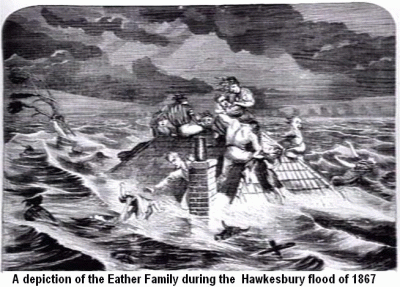
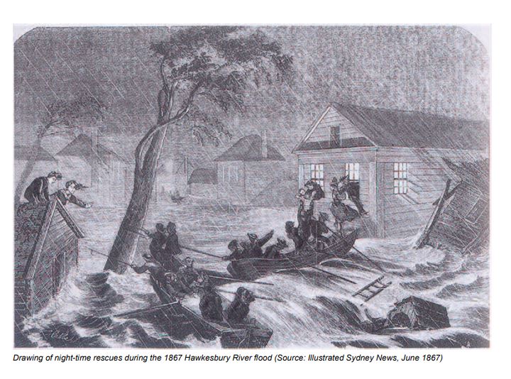
- 1867, June 23—Rose 63.2 feet (19.3m) Six lives were lost. Record flood, fifteen feet above the highest known.
- 1869, May 9—Rose 36.8 feet.
- 1870, April 28—Rose 45 feet. May 13-14—Rose 35.5 feet. Record wet year, 62.51 inches of rain falling. Seven big rises in the river.
- 1871, May 2—Rose 36.9 feet.
- 1873, February 26-27—Rose 41.6 feet.
- 1875, June 7—Rose 38.9 feet.
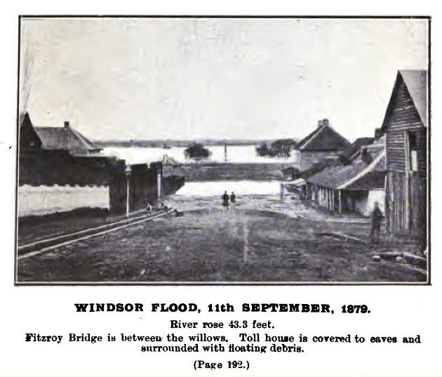
- 1879, September 11—Rose 43,3 feet.
- 1889, May 29—Rose 38.5 feet.
- 1890, March 13—Rose 38.9 feet. Three floods this year. 45.67 inches of rain fell.
- 1891, June 26—Rose 35.5 feet.
- 1900, July 7—Rose 46.2 feet.
- 1904, July 12—Rose 40.1 feet.
-
Conversions: 40 feet is 12.2 meters. 45 feet is 13.7m and 50 feet is 15.2 m. 63 feet is 19.3m.
————————————
1869 Floods — Source: Gutenberg ebooks
Snippets from flooding in the later half of the 1800s:
In the year 1842 a neat brick church was built at Clydesdale and named St. Phillip’s, the parish being from then known as “Windsor and Clydesdale”. Unfortunately, this church was built on the flood area, the big flood in 1867 leaving drift wood on the roof. This church is now closed.
…the Big Flood, 23rd June, 1867, when the river rose to the extraordinary height of sixty-three feet, and six lives were lost.
The Rev. H.T. Stiles died on the 22nd June, 1867, within two days of his sixtieth birthday. His death occurred while the big flood was at about its greatest height, the water having entered the Presbyterian Church in George Street, where large numbers of refugees had slept the previous night. The last duty performed by the dying minister was to order that the church doors of St. Matthew’s be opened in order to let the homeless people find a shelter from the rising flood.
A water brigade was formed in 1872, to be in readiness in case of flood, and to become proficient in the management of the flood boats. The members were Messrs. J. A. Dick, Wm. Moses, R.D.W. Walker, W. Gosper, W.F. Linsley, W. Alderson, and E.J. Tout.
THE danger from floods is always a source of anxiety to the occupants of the low-lying lands along the banks of the Hawkesbury; the river may rise and overflow its banks at any time during the whole year.
The tragic stories of families lost due to NSW floods is written up in Family Tree Circles.
See also History of the Floods of the Hawkesbury (J.P. Josephson), 1795-1881.