Kenneth Richard at NoTricksZone, found some studies showing Fires are less common today than in the past — including a ripper of an Australian study.
Emma Rehn et al went to a small lake in far North Australia and dug up about 6m of sediment core from the bottom. They looked at charcoal deposits and a bunch of different minerals. They discovered that the top most recent layers had the worst fires for a thousand years. It had all the makings of a Great Climate Change advert. But to their absolute credit, they kept going down and further back and uncovered a story of four thousand long years of wild blazes.
Despite millennia of prehistoric infernos, no media outlets in Australia have shown any interest in this study which came out a month ago — showing Sensationalism is not all its cracked up to be, and not as much fun as Confirmation Bias.
Look at the current blip (left hand side) since European settlement, compared to the fires of 4,000 years ago (right hand side). As Mr Dundee would say, “That’s not a fire…. ”
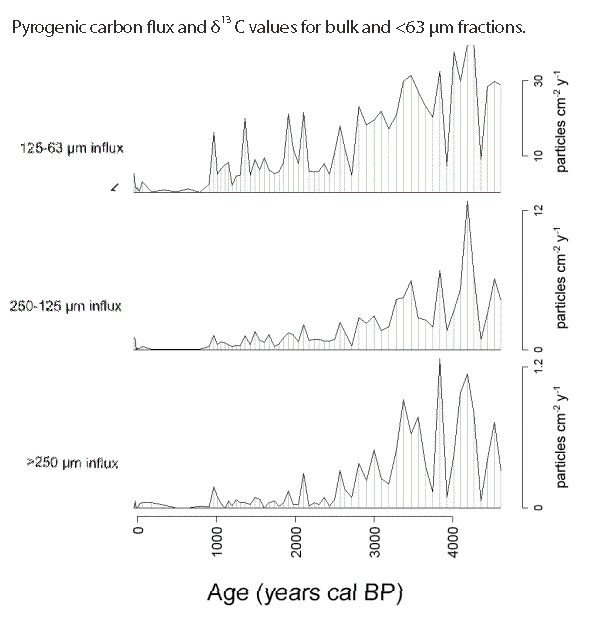
Carbon Flux showing the intensity of fires in Arnhem land for the last 5000 years.
The authors took mineral samples, looked at the different sizes of the charcoal particles. They decided that there were cycles of intense fires every 450 years in the era around 3 – 5,000 years ago largely driven by the climate. (Which climate models explain those cycles?)
There was also more rain around 4,000 years ago, which — rather than reducing fires — may have fueled the biomass growth that led to intense wildfires.
In the last 2,500 years ago, things got drier and more variable, and people who liked to eat a lot of mudflat shellfish moved into the area. Apparently they did more local fire management too. They appear to have been lighting more smaller fires. That, and the drier conditions meant there wasn’t the bulk biomass lying around to fuel the infernos we’ve come to expect from the modern Department of Planning, Industry and Environment.
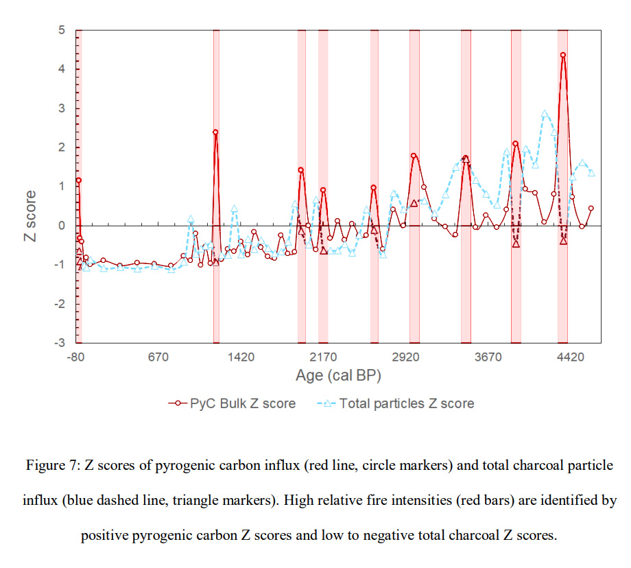
The z-scores graph brings out the highest intensity fire periods.
The present is on the left (again).
Arnhem Land Fires were far worse 3,000 to 5,000 years ago and once had cycles of high intensity every 450 years.
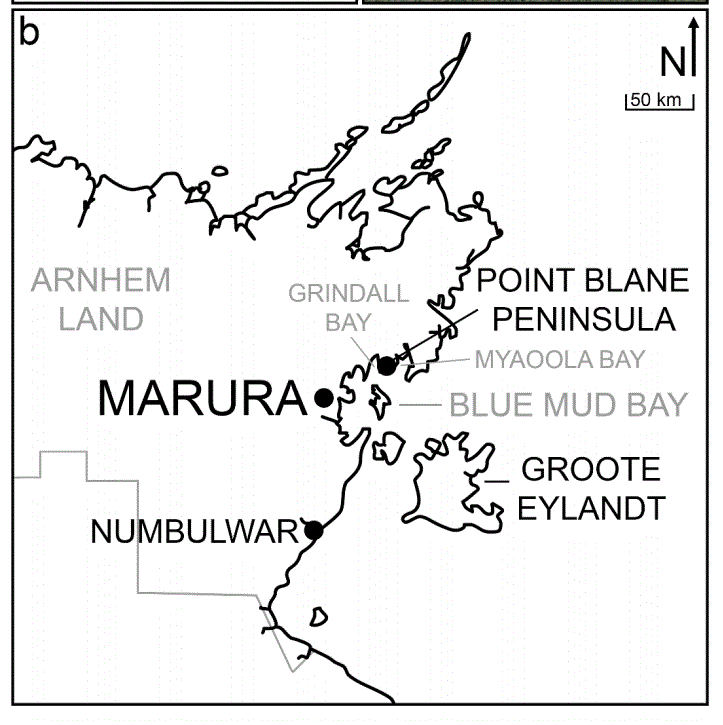
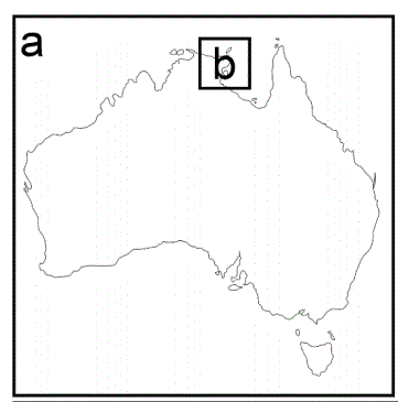
Marura, NT
Then a strange thing happened around 900 years ago when there was hardly any charcoal in the mud sediments. The people at the time ate less shellfish and appeared to wander around more. The fires seem to be small regular patchwork fires.
Then in the last 200 years, European people arrived, mucked up the neat patterns and big fires came back again for the first time in a thousand years. Though the top layers of mud were stirred up in the little lake, so actual dates are blurry. But historical records describe what happened.
We knew the fires were big, we just didn’t realize how unusual they were.
Of course even bigger and stupider fires occurred in the last twenty years far away on the East coast of Australia. Experts decided they would protect koalas and spotted quolls by stopping all the small fires and grazing cows. Thus letting an incendiary tonnage of fuel build up so they could generate proper pyroclastic infernos that sterilize the Earth.
The new genius plan is to use solar panels and windmills to ward off Dem’ Big Climate Apocalypsy.
Stone Age science is so much more advanced than Politically Correct Science.
What happened in the last 200 years:
Arnhem Land was under pastoral lease from the late 19th to early 20th 1 centuries, before the establishment of the Arnhem Land Aboriginal Reserve in 1931 (Barrier Miner 1931; Cole 1982). Russell-Smith et al. (1997, p.180) noted the prevalence of intense late dry season fires in western Arnhem Land beginning in the last century with the “collapse of traditional management practice”, with such fires becoming commonplace after the 1940s. Changes in settlement patterns also led to altered fire management in areas such as Arnhem Land even after management was returned to traditional owners (see Head 1994, p.177). This is potentially reflected by high bulk pyrogenic carbon influx in the most recent samples from Marura, suggesting high fire intensities as associated with European-influenced or unmanaged late dry season burns; however, lead-210 dating results suggest mixing in the uppermost 10 cm of sediment and therefore no definitive conclusions can be drawn regarding the most recent period within the Marura record
For anyone wondering why they think Phase II had more man-made burning:
Through indications such as short, alternating fire intensity phases and decoupling of bulk pyrogenic carbon δ13 C values from fire intensity changes, the fire record in Phase II is considered to be human-driven. This style of burning, as active fire management, is well documented; multiple studies by Bliege Bird et al. (2008, 2012, 2013) described mosaic burning for subsistence in the Western Desert creating landscape patchiness, functioning as a buffer to climate-driven large scale fires and promoting species such as varanid lizards that require both burnt and unburnt habitat patches. Russell-Smith et al. (1997) detailed similar methods of burning for resource management in western Arnhem Land, and these methods are now utilised by over 70 registered savanna burning projects across northern Australia (Ansell et al. 2019).
Abstract
Fire has a long history in Australia and is a key driver of vegetation dynamics in the tropical savanna ecosystems that cover one quarter of the country. Fire reconstructions are required to understand ecosystem dynamics over the long term but these data are lacking for the extensive savannas of northern Australia. This paper presents a multiproxy palaeofire record for Marura sinkhole in eastern Arnhem Land, Northern Territory, Australia. The record is constructed by combining optical methods (counts and morphology of macroscopic and microscopic charcoal particles) and chemical methods (quantification of abundance and stable isotope composition of pyrogenic carbon by hydrogen pyrolysis). This novel combination of measurements enables the generation of a record of relative fire intensity to investigate the interplay between natural and anthropogenic influences. The Marura palaeofire record comprises three main phases: 4600–2800 cal BP, 2800–900 cal BP and 900 cal BP to present. Highest fire incidence occurs at ~4600–4000 cal BP, coinciding with regional records of high effective precipitation, and all fire proxies decline from that time to the present. 2800–900 cal BP is characterised by variable fire intensities and aligns with archaeological evidence of occupation at nearby Blue Mud Bay. All fire proxies decline significantly after 900 cal BP. The combination of charcoal and pyrogenic carbon measures is a promising proxy for relative fire intensity in sedimentary records and a useful tool for investigating potential anthropogenic fire regimes.
REFERENCE
Rehn, E. et al (2021) A late-Holocene multiproxy fire record from a tropical savanna, eastern Arnhem Land, Northern Territory, Australia [PDF]