We’ve seen the remarkable change of the Rutherglen record as it got homogenized. This long running rural record that looks ideal apparently had “unrecorded” station moves found by thermometers miles away. Already we have found Bill Johnston who did some work at Rutherglen who confirmed that the station did not move. The mystery grows?
Since early 2012 Ken Stewart has been asking the BOM which neighbouring stations were used. Finally, after pressure from The Australian, the BOM has provided the 17 names, and Ken has graphed them.
Follow the chart below. Rutherglen temperatures start off in blue. The yellow line is the average of the 17 “neighbours” which are used to homogenize that blue line and transform it into the red one which somehow ends up being colder than its neighbours in 1952 and warmer than its neighbours in all the last 30 years.
See if you can figure it out?
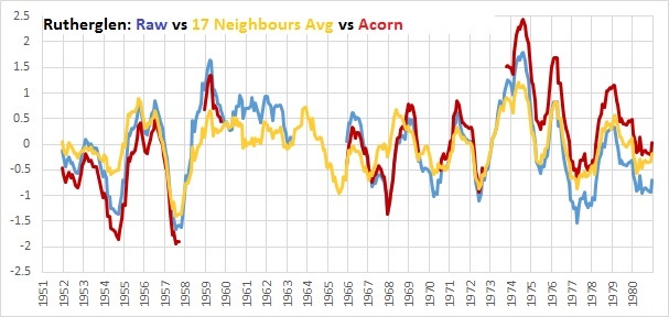
Rutherglen starts off blue. Then the yellow line is used to homogenize that blue line into the red one.
Presumably the BOM technique would be a lot more complicated that what Ken has done, but clearly replicating that ACORN final trend is not going to be easy.
The 17 neighbouring places stretch from Beechworth in the foothills of the Victorian Alps, to Hillston on the flat plains of hot New South Wales. Hillston is about 370km by road from the wine growing district of Rutherglen. It’s 300km direct according to this estimate. Hey but maybe their climate trends are more similar than they appear…
Hillston is the top left red dot on the map below.
74034 Corowa, 82053 Wangaratta, 82002 Benalla, 72097 Albury Pumping Station, 82100 Bonegilla
74106 Tocumwal, 81049 Tatura, 81084 Lemnos, 72023 Hume Reservoir, 82001 Beechworth
72150 Wagga Wagga, 74114 Wagga Research Centre, 80015 Echuca, 74039 Deniliquin (Falkiner Memorial)
74062 Leeton, 74128 Deniliquin, and 75032 Hillston.

The stations used in adjusting the Rutherglen record (Click to enlarge)
Here’s the temperature trends of Hillston at the BOM site. About 100km north of Griffith, NSW. Curiously from the BOM page you’d almost think Hillston, population 1,054, had an airport in 1912. Now that would be something…
Ken Stewart is doing an excellent job. But why is publicly checking our national database something that’s left to volunteers?